Storm Summary with Scattered Profile of the 2007-2008 Winter
Season (November - April) - 60 Storms
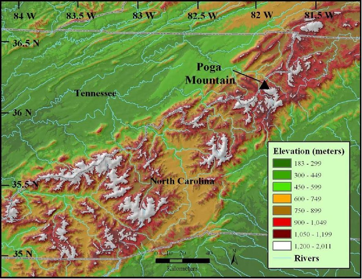
Poga Mountain, North Carolina ( Elevation: 1137 m)
|
|
| Home
Storm Summary of the 2006-2007 Winter Season (November - April)
Storm Summary of the 2007-2008 Winter Season (November - April)
Storm Summary of the 2008-2009 Winter Season (November - April)
SWE = Snow-water equivalent
Blue highlighted rows: Snow, freezing rain, sleet, or mixed cases
Grey highlighted rows: Virga or mix of virga and rain, no snow
| * = average for snow days only |
| ** = general trend 6 hours before storm |
| Tall |
(> 4.0 km AGL) |
|
Continuity for Storm Maturity |
| Borderline |
( 2.5-4.0 km AGL) |
|
Scattered: Several Breaks |
| Shallow |
(< 2.5 km AGL) |
|
|
|
 |
| Storm Summary |
Rain |
|
Rain to Virga (to Rain) |
|
Virga to Rain (to Virga) |
|
Rain/Virga |
|
Rain to Snow |
|
Snow (to Virga) |
|
Virga (to Rain) to Snow |
|
Virga (to Snow to Virga) |
|
|
| Continuity |
Continuous |
|
Scattered |
|
Continuous (Snow) |
|
Scattered (Snow) |
|
|
| AGL |
Tall |
|
Tall to Borderline |
|
Tall to Shallow |
|
Borderline |
|
Borderline to Shallow |
|
Borderline to Tall |
|
Shallow (to Tall) |
|
|
| Average |
All |
Page |
Temp. (°C) |
5.1 |
4.7 |
Wind Direction |
218° |
227° |
Wind Speed (m/s) |
3.3 |
3.2 |
Duration (hrs) |
14.8 |
15.7 |
Snowfall (in) * |
0.33 |
1.17 |
|
|
|
|
Trends |
Wind Direction |
Temperature |
RH |
Pressure |
Year |
Month |
Day |
Type |
AGL |
Start Time (UTC) |
Duration (hrs) |
Avg. Temp. (°C) |
Avg. |
At Snow Storm Maturity |
Wind Speed (m/s) |
Snowfall (in) |
SWE (in) |
before** |
during |
before** |
during |
before** |
during |
2007 |
11 |
6 |
|
Tall to Borderline |
01:30 |
9 |
8.5 |
W |
-- |
2.9 |
-- |
-- |
decreasing |
decreasing |
increasing |
increasing |
decreasing |
decreasing |
2007 |
11 |
9 |
|
Borderline |
22:30 |
4.5 |
6.4 |
W |
-- |
2.7 |
-- |
-- |
decreasing |
decreasing |
down - up |
increasing |
decreasing |
decreasing |
2007 |
11 |
12 |
|
Tall to Borderline |
05:00 |
6 |
8.8 |
SW |
-- |
1.3 |
-- |
-- |
decreasing |
increasing |
decreasing |
increasing |
increasing |
flat |
2007 |
11 |
13 |
|
Tall to Borderline |
00:00 |
40 |
10.0 |
W |
-- |
1.9 |
-- |
-- |
decreasing |
increasing |
increasing |
increasing |
decreasing |
decreasing |
2007 |
11 |
14 |
|
Tall to Shallow |
23:00 |
25 |
4.7 |
SW |
NW |
3.5 |
0.1 |
0.01 |
increasing |
decreasing |
decreasing |
up - down |
decreasing |
down - up |
2007 |
11 |
19 |
|
Borderline |
10:30 |
10 |
9.6 |
W |
-- |
2.0 |
-- |
-- |
down - up |
flat |
decreasing |
increasing |
decreasing |
up - down |
2007 |
11 |
22 |
|
Tall to Shallow |
00:30 |
25 |
9.4 |
SW |
NW |
2.2 |
trace |
0.02 |
decreasing |
decreasing |
increasing |
increasing |
decreasing |
down - up |
2007 |
11 |
25 |
|
Tall |
00:00 |
24 |
5.7 |
SE |
-- |
1.8 |
-- |
-- |
decreasing |
increasing |
increasing |
increasing |
decreasing |
decreasing |
2007 |
11 |
26 |
|
Tall to Shallow |
09:30 |
27 |
10.0 |
SW |
-- |
3.5 |
-- |
-- |
increasing |
decreasing |
flat |
flat |
decreasing |
down - up |
2007 |
12 |
7 |
|
Tall |
4:30 |
15.5 |
1.9 |
SE |
SE |
1.8 |
trace |
0.01 |
decreasing |
increasing |
increasing |
up - down |
increasing |
flat |
2007 |
12 |
8 |
|
Borderline |
13:00 |
14.5 |
11.7 |
W |
-- |
2.3 |
-- |
-- |
increasing |
increasing |
increasing |
increasing |
increasing |
increasing |
2007 |
12 |
12 |
|
Tall |
17:00 |
5.5 |
12.9 |
W |
-- |
2.3 |
-- |
-- |
increasing |
decreasing |
flat |
increasing |
flat |
flat |
2007 |
12 |
13 |
|
Shallow to Tall |
16:30 |
7 |
12.3 |
NW |
-- |
3.7 |
-- |
-- |
increasing |
decreasing |
decreasing |
increasing |
decreasing |
down - up |
2007 |
12 |
15 |
|
Tall to Shallow |
20:00 |
33.5 |
-1.9 |
SE |
S |
4.8 |
4.1 |
0.11 |
decreasing |
decreasing |
increasing |
decreasing |
decreasing |
down - up |
2007 |
12 |
19 |
|
Borderline to Shallow |
9:30 |
5 |
-0.4 |
SW |
W |
2.0 |
trace |
0.01 |
increasing |
increasing |
flat |
increasing |
decreasing |
flat |
2007 |
12 |
20 |
|
Tall |
23:00 |
17.5 |
1.1 |
E |
-- |
5.3 |
-- |
-- |
decreasing |
decreasing |
increasing |
flat |
decreasing |
increasing |
2007 |
12 |
22 |
|
Tall |
21:30 |
19 |
7.0 |
SE |
-- |
5.2 |
-- |
-- |
increasing |
increasing |
flat |
decreasing |
decreasing |
decreasing |
2007 |
12 |
25 |
|
Tall to Borderline |
20:00 |
18.5 |
1.7 |
SW |
-- |
2.4 |
-- |
-- |
increasing |
decreasing |
decreasing |
increasing |
decreasing |
decreasing |
2007 |
12 |
28 |
|
Tall to Borderline |
15:00 |
16 |
9.5 |
SE |
-- |
3.3 |
-- |
-- |
increasing |
increasing |
decreasing |
flat |
flat |
decreasing |
2007 |
12 |
30 |
|
Tall to Shallow |
13:00 |
13 |
5.0 |
SW |
-- |
2.4 |
-- |
-- |
flat |
up - down |
increasing |
increasing |
decreasing |
decreasing |
2008 |
1 |
1 |
|
Shallow |
8:00 |
23 |
-9.4 |
NW |
NW |
4.6 |
4.0 |
0.13 |
increasing |
decreasing |
decreasing |
increasing |
decreasing |
increasing |
2008 |
1 |
6 |
|
Tall |
6:00 |
14.5 |
8.7 |
SW |
-- |
1.4 |
-- |
-- |
increasing |
increasing |
increasing |
decreasing |
decreasing |
up - down |
2008 |
1 |
9 |
|
Tall to Shallow |
5:00 |
7 |
11.1 |
SE |
-- |
3.5 |
-- |
-- |
increasing |
up - down |
flat |
increasing |
decreasing |
increasing |
2008 |
1 |
10 |
|
Tall |
8:30 |
5.5 |
3.2 |
S |
-- |
2.8 |
-- |
-- |
decreasing |
decreasing |
up - down |
increasing |
flat |
decreasing |
2008 |
1 |
11 |
|
Tall |
0:00 |
13 |
9.2 |
S |
-- |
3.9 |
-- |
-- |
increasing |
decreasing |
increasing |
down - up |
decreasing |
decreasing |
2008 |
1 |
13 |
|
Tall to Shallow |
13:00 |
28 |
-0.8 |
SW |
NW |
3.0 |
0.6 |
0.04 |
decreasing |
decreasing |
increasing |
decreasing |
decreasing |
flat |
2008 |
1 |
15 |
|
Shallow |
11:30 |
4.5 |
-8.4 |
NW |
NW |
4.9 |
0.2 |
0.01 |
decreasing |
increasing |
flat |
increasing |
flat |
increasing |
2008 |
1 |
19 |
|
Tall |
5:30 |
21 |
-4.0 |
W |
NW |
2.3 |
0.4 |
0.04 |
decreasing |
decreasing |
decreasing |
increasing |
increasing |
decreasing |
2008 |
1 |
22 |
|
Borderline to Tall |
14:00 |
12 |
2.9 |
SW |
-- |
1.5 |
-- |
-- |
increasing |
up - down |
flat |
increasing |
flat |
decreasing |
2008 |
1 |
24 |
|
Shallow |
12:00 |
14 |
-7.1 |
NW |
NW |
4.7 |
0.8 |
0.04 |
decreasing |
decreasing |
increasing |
decreasing |
flat |
increasing |
2008 |
1 |
26 |
|
Tall to Borderline |
3:00 |
12 |
-4.2 |
SW |
-- |
1.2 |
-- |
-- |
decreasing |
decreasing |
increasing |
increasing |
decreasing |
decreasing |
2008 |
1 |
29 |
|
Tall |
0:00 |
12 |
6.9 |
S |
-- |
1.5 |
-- |
-- |
decreasing |
flat |
flat |
flat |
flat |
increasing |
2008 |
1 |
29 |
|
Tall to Borderline |
21:30 |
10 |
7.0 |
SE |
-- |
3.9 |
-- |
-- |
decreasing |
decreasing |
increasing |
increasing |
decreasing |
decreasing |
2008 |
1 |
31 |
|
Tall to Borderline |
15:30 |
26.5 |
0.5 |
SE |
-- |
5.9 |
-- |
-- |
increasing |
increasing |
decreasing |
increasing |
increasing |
decreasing |
2008 |
2 |
10 |
|
Borderline |
18:30 |
2 |
0.8 |
W |
-- |
6.7 |
-- |
-- |
increasing |
decreasing |
increasing |
increasing |
flat |
flat |
2008 |
2 |
12 |
|
Tall |
14:30 |
6 |
6.8 |
S |
-- |
4.6 |
-- |
-- |
increasing |
decreasing |
flat |
increasing |
decreasing |
decreasing |
2008 |
2 |
13 |
|
Borderline to Tall to Shallow |
5:00 |
11.5 |
6.2 |
SW |
-- |
2.6 |
-- |
-- |
increasing |
decreasing |
increasing |
increasing |
decreasing |
decreasing |
2008 |
2 |
19 |
|
Borderline |
1:30 |
21 |
-2.9 |
W |
W |
4.3 |
0.1 |
0.01 |
decreasing |
down - up |
decreasing |
flat |
increasing |
increasing |
2008 |
2 |
20 |
|
Borderline |
19:00 |
4 |
5.7 |
W |
-- |
5.4 |
-- |
-- |
increasing |
decreasing |
decreasing |
increasing |
decreasing |
increasing |
2008 |
2 |
22 |
|
Borderline to Tall |
13:00 |
5 |
7.5 |
SE |
-- |
1.8 |
-- |
-- |
increasing |
increasing |
increasing |
down - up |
decreasing |
decreasing |
2008 |
2 |
23 |
|
Borderline to Shallow |
12:00 |
6.5 |
4.2 |
NW |
-- |
2.8 |
-- |
-- |
decreasing |
decreasing |
flat |
down - up |
flat |
increasing |
2008 |
2 |
26 |
|
Tall to Shallow |
4:30 |
63 |
-4.3 |
W |
NW |
4.4 |
8.3 |
0.39 |
decreasing |
decreasing |
increasing |
up - down |
decreasing |
increasing |
2008 |
2 |
29 |
|
Shallow to Tall to Borderline |
9:00 |
22 |
0.3 |
S |
SE |
2.2 |
0.4 |
0.13 |
increasing |
increasing |
decreasing |
increasing |
increasing |
decreasing |
2008 |
3 |
8 |
|
Tall to Shallow |
1:30 |
25.5 |
0.6 |
SW |
NW |
4.4 |
1.5 |
0.11 |
increasing |
increasing |
increasing |
decreasing |
decreasing |
increasing |
2008 |
3 |
14 |
|
Tall |
16:00 |
11.5 |
9.7 |
SW |
-- |
2.9 |
-- |
-- |
increasing |
decreasing |
decreasing |
increasing |
decreasing |
down - up |
2008 |
3 |
15 |
|
Tall to Shallow |
16:30 |
12 |
7.1 |
SW |
-- |
2.9 |
-- |
-- |
increasing |
decreasing |
decreasing |
increasing |
flat |
down - up |
2008 |
3 |
19 |
|
Tall to Shallow |
15:30 |
21 |
6.2 |
SW |
NW |
4.6 |
0.7 |
0.17 |
increasing |
decreasing |
down - up |
down - up |
decreasing |
down - up |
2008 |
3 |
24 |
|
Borderline to Shallow |
17:00 |
10 |
-3.1 |
NW |
NW |
3.7 |
0.4 |
0.02 |
increasing |
decreasing |
decreasing |
increasing |
increasing |
increasing |
2008 |
3 |
28 |
|
Shallow to Tall |
16:00 |
23.5 |
10.1 |
SW |
-- |
2.2 |
-- |
-- |
increasing |
decreasing |
increasing |
increasing |
increasing |
increasing |
2008 |
3 |
31 |
|
Tall |
10:30 |
25.5 |
10.0 |
SE |
-- |
2.8 |
-- |
-- |
increasing |
increasing |
flat |
down - up |
decreasing |
decreasing |
2008 |
4 |
2 |
|
Borderline |
22:00 |
2 |
11.6 |
NW |
-- |
1.1 |
-- |
-- |
increasing |
decreasing |
decreasing |
flat |
decreasing |
increasing |
2008 |
4 |
3 |
|
Tall |
7:00 |
18.5 |
4.4 |
E |
-- |
4.6 |
-- |
-- |
decreasing |
flat |
increasing |
increasing |
flat |
decreasing |
2008 |
4 |
4 |
|
Borderline to Tall |
18:00 |
34 |
9.2 |
SW |
-- |
2.4 |
-- |
-- |
up - down |
decreasing |
down - up |
flat |
decreasing |
up - down |
2008 |
4 |
11 |
|
Tall |
22:30 |
14.5 |
14.9 |
SW |
-- |
2.1 |
-- |
-- |
decreasing |
decreasing |
increasing |
increasing |
decreasing |
decreasing |
2008 |
4 |
13 |
|
Shallow |
5:00 |
1.5 |
4.6 |
W |
-- |
4.6 |
-- |
-- |
decreasing |
decreasing |
increasing |
increasing |
increasing |
flat |
2008 |
4 |
13 |
|
Borderline to Shallow |
18:00 |
11 |
2.7 |
NW |
NW |
4.4 |
0.3 |
0.06 |
flat |
decreasing |
flat |
increasing |
increasing |
increasing |
2008 |
4 |
14 |
|
Borderline |
16:30 |
14.5 |
-0.9 |
NW |
NW |
2.9 |
0.4 |
0.08 |
increasing |
decreasing |
decreasing |
increasing |
increasing |
increasing |
2008 |
4 |
19 |
|
Tall to Borderline to Tall |
10:00 |
14.5 |
12.4 |
SE |
-- |
2.9 |
-- |
-- |
decreasing |
up - down |
increasing |
increasing |
decreasing |
decreasing |
2008 |
4 |
20 |
|
Borderline |
9:30 |
13.5 |
6.3 |
NW |
-- |
2.3 |
-- |
-- |
decreasing |
increasing |
down - up |
decreasing |
decreasing |
increasing |
2008 |
4 |
29 |
|
Borderline to Tall to Borderline |
1:00 |
6.5 |
3.2 |
W |
NW |
3.6 |
trace |
0.03 |
up - down |
decreasing |
down - up |
up - down |
increasing |
up - down |
Version 1.2, 18 August 2011
web page credits: Micheal Tai Bryant, Sandra Yuter, L. Baker Perry
This research is a collaboration between the
Department of Marine, Earth, and Atmospheric Sciences, North Carolina State University
and the Department of Geography and Planning, Appalachian State University
contacts:
Dr. Sandra Yuter seyuter@ncsu.edu
Dr. L. Baker Perry perrylb@appstate.edu